The Western Ghats that border my tiny state of Kerala in the east, runs along its entire length, and most of my weekends end on some heights of this mountain stretch. It wasn't amazing, to learn that many of my foreign friends envy me on this treasure, near by. The treasure hidden under the foliage are vivid, be it the endemic flora and fauna or the remains of historic invasions. These wooded mounts have been home for mankind for long and mother nature had been kind enough, to preserve at least a part of what they left behind. These include the paintings of Ezhuthu guha in Marayoor, that dates back to 10000BC, to the comparatively recent Tramway of Parambikulam .
The stretch, east to the city of Trivandrum, the erstwhile Travancore, were generally known as Ashambu hills, and the British who ruled India, had an eye on the revenue, that can be tapped from these hillocks. They established coffee plantations, clearing the woods by 1860. But that didn't flourish, due to unforeseen disease and it got transformed to Tea plantations by 1884. These adjacent estates where then named 'Braemore', 'Merchiston', 'Bon Accord', 'Athirumala' and so on. Among these the Athirumala venture was dropped soon, I think, and the other three were brought under a consortium by name 'The Ponmudi Tea and Rubber Company Ltd.', in the year 1900. The total planted area was 1710 acres. These estate premises are inhabited now and locally known as 'Brymoor', 'Ponmudi' and 'Bonakkadu'. The plantations faced lockout and are in ruins now.
As you know, motor vehicles hadn't hit roads then and means of transport were either bullock carts or horses. Thus a horse track is thought to have been cleared through the woods, for the plantation workers or even the owners, to travel between the estates. Eventually separate roads were built to these estates, motor trucks were introduced and the good old bridle path along the elevation, was deprived of gallops. The then State of Travancore was shared between the newly formed states of Kerala and Tamil Nadu, Forest Act came into force, those elevated sectors were declared reserves, and the bridle path left to the nature.
One fine morning, about a century later, four of us, Pramod, Sujith, Nasar and the blogger, were driving towards Vithura, about 30 km from Trivandrum, destination decided as 'PandiPattu'. And this was how it took shape.
Got into research, on the present stage of the gallop path, and our good friends in the Forest dept. were of real help. Came to know that part of the old track from Ponmudi to Athirumala, which shall also be traversed down to Kaarayar of Tamil Nadu, can still be identified in the woods. At higher elevation, this track runs through grass hills, and fire line is being cleared by the dept. along this old track. At about 10 miles, along the track from Ponmudi, there was a horse shelter, and the region was named 'PandiPathu', by the then riders. - (Tamil speaking region was earlier known as Pandi Nadu and 'Pathu' is the digit ten). Exciting part of the narration was that the old horse shelter had undergone slight betterment and that, a stay shall be arranged, at that historic place, if so wished. Wikimapia lovers may click here for the location.
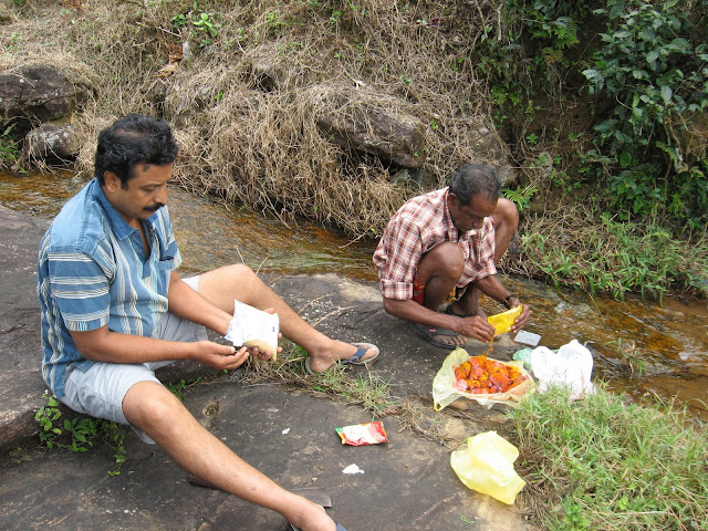
Stopped at Vithura and loaded the vehicle with provisions and had the luxury of broiler too. Took a right turn at Theviyode, just after Vithura, and headed along the road to Bonakkadu - of course the old 'Bon - Accord'. A 10 km drive took us to 'Kaanithadam' Forest Check post, where Mr. Varghese, a watcher with the forest dept, was all equipped to assist us, on directions from the officer in charge of the place, Mr. Sethu. Got him into our vehicle and continued further.
Surroundings switched soon and we were driving along the jungles of Pepppara range. Road wasn't that bad and the drive was smooth. Within this short while, could strengthen the bond with our guide, and we turned listeners. We were surprised to hear that this man was of 76 years and has been serving the dept for the last 25 years. Bus service is there up to Bonacaud, thrice a day, for the estate staff of the locked out plantation, who still stick on, as they weren't paid compensation.
Drove up to the end station of Bus service and took a left deviation. For the next 7 kms, the track condition was that bad, we crawled with our WagonR, to cover the stretch, in almost an hour. Finally parked the vehicle by the way side and got geared for the trek.

Stopped at a brook, had the dosas we carried along, while Varghesettan cleaned the broiler and packed it.
The initial stretch of about one km through the abandoned tea estate was extremely steep and we had several stops, not to break our lungs.

But Varghesettan rocketed up and was found waiting at many places, for the younger chaps, to keep up with him.

At the end of this tedious stretch, we joined the horse track, that suddenly appeared from the woods. Few steps ahead we hit upon the milestone indicating the seventh mile, by the track side.

The pipe laid by the British, to bring water from the hills to the estate, ran along the track and was still in duty, though slightly leaking at places.

The track entered the jungle and the gradient of the climb lessened. Followed the track, just boulders at places and wide as a jeep track occasionally. Could hear the flow of Kallar - known as Vamanapuram river at a later stage, to our left. To the other side of the flow, located tall mountains, with heavy growth of reeds, paradise of elephants, for sure.

Within half an hour, the jungle cover opened to grass hillocks, and could spot the ninth mile stone, hidden in the foliage.

It was then, we noticed that the eighth mile stone was missing. Even Varghesettan is unaware, where the thing had disappeared.
Now we could spot the shelter at a distance, about a quarter mile ahead, bordered by the towering Chemmunchi hills, at the back drop.

It started slightly drizzling then, spreading mist, and the walk went brisker. Crossed the trench and ran to the shelter. It was just a room and a kitchen, with two wire beds. Went into search for utensils and found that those for making chapatti, weren't available. Sujith was entrusted with the making of a customary one and we went out, with Varghesettan, for bringing water.

Chemmunchi hills in the east, just behind our shelter, is where two major rivers of Trivandrum district originates - Vamanapuram River and Karamana River. We were left with the option of either walking north for Vamanapuram River or to the south for Karamana River. Headed south for Karamana River, which caters to our home town, and it was just a five minutes walk. The infant river was tear clear, and we were back soon, generously feeding leaches.
The drizzle strengthened then and we simply sat watching rain in the hills. Varghesettan was busy in the kitchen, struggling to lit the wet logs, for our chicken dish.

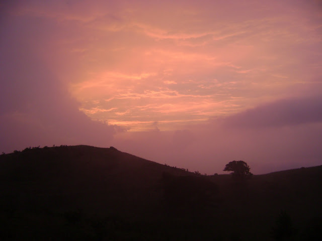
Rain subsided by dusk and we went for a short walk, to the hillock to our west. It ended at a ridge, presenting the scenario of the valleys of Bonacaud.


Did not dare to walk to the edges, as the wind was strong enough to grand us a fly.


Temperature dropped and couldn't resist the wind supported chill for long.

Returned to the shelter, once again pleasing the leaches.

Varghesettan was ready with the chicken curry and it was the turn for Sujith, to go ahead with Chapatis.

Dined and opted to hit the sack soon, as we were all worn out. The wind howled through out the night, often disturbing my sleep.
Woke up early and ventured out, daring the chill, expecting Bisons or Pachyderms around, but none turned up. Hit Karamana river for the fresh up, and left over from the previous night, made a delicious break fast. As planned earlier, got out to trek to the State limits, where the Tenth Mile stone - Pandi pattu, awaited us. Crossed Karamana River and entered a shola wood sector. Half a km through the woods and grass hillocks appeared again, to our right, with shola woods to our left.


The greenery and the mist played such a magic that none of us talked or walked. Howl of the wind and the camera clicks were the lone waves audible.

Thus strolling, consuming about an hour for just around one km, stopped to see that our track split. Out of the magical spell, to find Varghesettan pointing to some thing and ran up to him. It was the Tenth Mile Stone, not upright, but lying on the ground.

This stone indicates the state border and it is the 'Mundanthurai' sector of the 'Kalakkad Mundanthurai Tiger Reserve' further ahead. Track to the right leads to 'Athirumala', close to 'Agastyar Koodam' and we continued along the left, which leads to Kaarayar of Tamil Nadu.

'The Travancore State Manual' published in 1906 has a mention on such bridle passes, across the Western Ghats, used by then smugglers, to cross over to Travancore from the Pandi Nadu
Crossed a brook and climbed up a hillock, to an incomplete structure, once intended for a watch tower.

The huge skull of a Bison, by the way side, stole away some time. Varghesettan says it would have been a tiger's catch.

At the foot hill, found a huge rocky structure, by the track side. Varghesettan says, people used to perform rituals at this place. Climbed up a near by hillock, to find that the top of the rock was amazingly flat.

Those early travelers, along this path, would have used the rock top for a night stay, to be safe from wild attacks and that might have resulted in considering it some thing divine.
Decided to end our trek here, as it wouldn't be fare to intrude, without permission. Varghesettan had done the entire stretch to Kaarayar and Banatheertham falls, at the foot hill, which is connected to Papanasam and Ambasamudram of Tamil Nadu, by good roads. I had been to Baanatheertham earlier, through the other side and it was amazing to learn that it was just another 12 km climb down, from where we were.
Returned to the shelter, along the same path and packed up for the descent. Aching legs took us down to the base, by around 12.30 PM.
Drove down the treacherous track to Bonacadu, and while having tea at a small joint over there, planned of having a dip in Thodayaar, which joins the Peppara reservoir, near Kaanithadam Check post. As Chemmancode tribal settlement was near by the flow, had a small walk to the place and returned along the reservoir side.
The stretch, east to the city of Trivandrum, the erstwhile Travancore, were generally known as Ashambu hills, and the British who ruled India, had an eye on the revenue, that can be tapped from these hillocks. They established coffee plantations, clearing the woods by 1860. But that didn't flourish, due to unforeseen disease and it got transformed to Tea plantations by 1884. These adjacent estates where then named 'Braemore', 'Merchiston', 'Bon Accord', 'Athirumala' and so on. Among these the Athirumala venture was dropped soon, I think, and the other three were brought under a consortium by name 'The Ponmudi Tea and Rubber Company Ltd.', in the year 1900. The total planted area was 1710 acres. These estate premises are inhabited now and locally known as 'Brymoor', 'Ponmudi' and 'Bonakkadu'. The plantations faced lockout and are in ruins now.
As you know, motor vehicles hadn't hit roads then and means of transport were either bullock carts or horses. Thus a horse track is thought to have been cleared through the woods, for the plantation workers or even the owners, to travel between the estates. Eventually separate roads were built to these estates, motor trucks were introduced and the good old bridle path along the elevation, was deprived of gallops. The then State of Travancore was shared between the newly formed states of Kerala and Tamil Nadu, Forest Act came into force, those elevated sectors were declared reserves, and the bridle path left to the nature.
One fine morning, about a century later, four of us, Pramod, Sujith, Nasar and the blogger, were driving towards Vithura, about 30 km from Trivandrum, destination decided as 'PandiPattu'. And this was how it took shape.
Got into research, on the present stage of the gallop path, and our good friends in the Forest dept. were of real help. Came to know that part of the old track from Ponmudi to Athirumala, which shall also be traversed down to Kaarayar of Tamil Nadu, can still be identified in the woods. At higher elevation, this track runs through grass hills, and fire line is being cleared by the dept. along this old track. At about 10 miles, along the track from Ponmudi, there was a horse shelter, and the region was named 'PandiPathu', by the then riders. - (Tamil speaking region was earlier known as Pandi Nadu and 'Pathu' is the digit ten). Exciting part of the narration was that the old horse shelter had undergone slight betterment and that, a stay shall be arranged, at that historic place, if so wished. Wikimapia lovers may click here for the location.
Stopped at Vithura and loaded the vehicle with provisions and had the luxury of broiler too. Took a right turn at Theviyode, just after Vithura, and headed along the road to Bonakkadu - of course the old 'Bon - Accord'. A 10 km drive took us to 'Kaanithadam' Forest Check post, where Mr. Varghese, a watcher with the forest dept, was all equipped to assist us, on directions from the officer in charge of the place, Mr. Sethu. Got him into our vehicle and continued further.
Surroundings switched soon and we were driving along the jungles of Pepppara range. Road wasn't that bad and the drive was smooth. Within this short while, could strengthen the bond with our guide, and we turned listeners. We were surprised to hear that this man was of 76 years and has been serving the dept for the last 25 years. Bus service is there up to Bonacaud, thrice a day, for the estate staff of the locked out plantation, who still stick on, as they weren't paid compensation.
Drove up to the end station of Bus service and took a left deviation. For the next 7 kms, the track condition was that bad, we crawled with our WagonR, to cover the stretch, in almost an hour. Finally parked the vehicle by the way side and got geared for the trek.

Stopped at a brook, had the dosas we carried along, while Varghesettan cleaned the broiler and packed it.

The initial stretch of about one km through the abandoned tea estate was extremely steep and we had several stops, not to break our lungs.

But Varghesettan rocketed up and was found waiting at many places, for the younger chaps, to keep up with him.

At the end of this tedious stretch, we joined the horse track, that suddenly appeared from the woods. Few steps ahead we hit upon the milestone indicating the seventh mile, by the track side.

The pipe laid by the British, to bring water from the hills to the estate, ran along the track and was still in duty, though slightly leaking at places.

The track entered the jungle and the gradient of the climb lessened. Followed the track, just boulders at places and wide as a jeep track occasionally. Could hear the flow of Kallar - known as Vamanapuram river at a later stage, to our left. To the other side of the flow, located tall mountains, with heavy growth of reeds, paradise of elephants, for sure.

Within half an hour, the jungle cover opened to grass hillocks, and could spot the ninth mile stone, hidden in the foliage.

It was then, we noticed that the eighth mile stone was missing. Even Varghesettan is unaware, where the thing had disappeared.
Now we could spot the shelter at a distance, about a quarter mile ahead, bordered by the towering Chemmunchi hills, at the back drop.

It started slightly drizzling then, spreading mist, and the walk went brisker. Crossed the trench and ran to the shelter. It was just a room and a kitchen, with two wire beds. Went into search for utensils and found that those for making chapatti, weren't available. Sujith was entrusted with the making of a customary one and we went out, with Varghesettan, for bringing water.

Chemmunchi hills in the east, just behind our shelter, is where two major rivers of Trivandrum district originates - Vamanapuram River and Karamana River. We were left with the option of either walking north for Vamanapuram River or to the south for Karamana River. Headed south for Karamana River, which caters to our home town, and it was just a five minutes walk. The infant river was tear clear, and we were back soon, generously feeding leaches.
 |
| Karamana River near its origin |

Rain subsided by dusk and we went for a short walk, to the hillock to our west. It ended at a ridge, presenting the scenario of the valleys of Bonacaud.


Did not dare to walk to the edges, as the wind was strong enough to grand us a fly.


Temperature dropped and couldn't resist the wind supported chill for long.


Returned to the shelter, once again pleasing the leaches.

Varghesettan was ready with the chicken curry and it was the turn for Sujith, to go ahead with Chapatis.

Dined and opted to hit the sack soon, as we were all worn out. The wind howled through out the night, often disturbing my sleep.
Woke up early and ventured out, daring the chill, expecting Bisons or Pachyderms around, but none turned up. Hit Karamana river for the fresh up, and left over from the previous night, made a delicious break fast. As planned earlier, got out to trek to the State limits, where the Tenth Mile stone - Pandi pattu, awaited us. Crossed Karamana River and entered a shola wood sector. Half a km through the woods and grass hillocks appeared again, to our right, with shola woods to our left.


The greenery and the mist played such a magic that none of us talked or walked. Howl of the wind and the camera clicks were the lone waves audible.

Thus strolling, consuming about an hour for just around one km, stopped to see that our track split. Out of the magical spell, to find Varghesettan pointing to some thing and ran up to him. It was the Tenth Mile Stone, not upright, but lying on the ground.

This stone indicates the state border and it is the 'Mundanthurai' sector of the 'Kalakkad Mundanthurai Tiger Reserve' further ahead. Track to the right leads to 'Athirumala', close to 'Agastyar Koodam' and we continued along the left, which leads to Kaarayar of Tamil Nadu.

'The Travancore State Manual' published in 1906 has a mention on such bridle passes, across the Western Ghats, used by then smugglers, to cross over to Travancore from the Pandi Nadu
Crossed a brook and climbed up a hillock, to an incomplete structure, once intended for a watch tower.

The huge skull of a Bison, by the way side, stole away some time. Varghesettan says it would have been a tiger's catch.

At the foot hill, found a huge rocky structure, by the track side. Varghesettan says, people used to perform rituals at this place. Climbed up a near by hillock, to find that the top of the rock was amazingly flat.

Those early travelers, along this path, would have used the rock top for a night stay, to be safe from wild attacks and that might have resulted in considering it some thing divine.
Decided to end our trek here, as it wouldn't be fare to intrude, without permission. Varghesettan had done the entire stretch to Kaarayar and Banatheertham falls, at the foot hill, which is connected to Papanasam and Ambasamudram of Tamil Nadu, by good roads. I had been to Baanatheertham earlier, through the other side and it was amazing to learn that it was just another 12 km climb down, from where we were.
Returned to the shelter, along the same path and packed up for the descent. Aching legs took us down to the base, by around 12.30 PM.
 | |
| View of Peppara reservoir from the return track |

 |
| Thodayaar about to join Peppara reservoir |
The history part was dug out from ''Southern India: its history, people, commerce, and industrial resources'' By J. W. Bond, Arnold Wright, written around 1914 and certain other details from 92 August edition of 'Economic and Political weekly', apart from my precious copy of "The Travancore State Manual".


nice.......... but u miss the ...specialitty of that area...... the shola grass lands in trivandrum
ReplyDeleteHi shinu
ReplyDeleteGood narration and photos
Another way to KMTR.
Thanks for sharing
my new post Attukal Pongala
Thank you both
ReplyDeleteI feel we should also try to climb the hills on the back of the shelter when we go there next time.
ReplyDeleteYeah, Chemmmunchi hill top should not be missed
ReplyDeleteThanks for another good report from you Shinu. It's great to see elephants at close range.
ReplyDeleteGreat reading Shinu.. :)
ReplyDeleteThanx Chris
ReplyDeleteAnd warm welcome Biju
DEAR SHINU, BEEN TO PANDIPATH NEARLY 5 TIMES IN THE EARLY 90S WITH A FRIEND OF MINE IN THE FOREST DEPT, A TRUE WLIFE PROFESSIONAL.ONLY DAY TIME TRIPS NO SHELTERS THEN. WHAT ATTRACTED ME WAS THE SERENE AND DESOLATE SOLITUDE OF THE GRASSLANDS STRETCHING AWAY AND AWAY, WHERE ONLY YOU , THE BLUE SKY, AND THE GRASSLANDS EXIST. YOU FEEL THE PRESENCE OF GOD THERE, IN THE FORM OF MOTHER NATURE. THE SILENCE , I FEEL, IS HEAVENLY. IT IS THE LAND OF GOD SHINU . SAW A GROUP OF GAUR ONCE 4 TO 5 IF I REMEMBER CORRECT, ALL YOUNGSTERS.MY FRIEND SAYS HE HAS SEEN EVIDENCE OF TIGER PRESENCE IN THE KARAMANAYAR SHOLA. ONE SUCH VISIT WAS ON A 1st JAN WHEN WE HAD TO CUT THRU ALONG WITH A GROUP OF REED CUTTERS FROM ADIPARAMBU. WISH TO GO ONCE MORE INSHA ALLAH.
ReplyDeleteMohan : Thanx for sharing ur experience. I agree with you in all sense. The presence of tiger is obvious as the region is contiguous with KM tiger reserve. And they are not bothered of boundaries
ReplyDeletesivakumar(sivakumar90mdu@gmail.com) :Great work sir ! It would be really helpful if you could tell us the route clearly !
ReplyDeleteSivakumar, I have clearly mentioned the route.
DeleteGood narration......
Deletethere was a narration of young chaps... Couldnt find any in the snaps:P Avarudey padam koodi edukkamayirunnu :D How will the bisons and pachyderms come out when they know 'puli' kattil erangi ;)
Hi Shinu
ReplyDeleteIts awesome..am a local boy from vithura:)
Thank You
Deletegreat stuff..Pandipath is one area which I want to go to at-least once. The nature of your writing is such that we feel like walking along with you. Looking forward for a more lengthy trip from your end to this wonderful place.
ReplyDeleteBonacaud has been a kind of mystery for me ever since my 1st visit in June 2010. The allure of the place is such that I visited Bonacaud 5 times till now, last one in Nov. 2011. Each time, something new comes up and I would dare to compare it to a gorgeous lady who reveals her ankle to tempt us :)
My best trip was the one in Sep. 2001 where we reached till the starting point of the Pandipath trek. It was around 4.30pm when we reached there, but with no intent to trek. Somehow, on that day, we had carried extra foods to last 2 days and 2 other guys then suddenly planned to take the trek or at-least part of it (call it as overdose of adrenalin. Rest 2 of us were not willing as we were without any guide/ jackets. Even by that time, wind was howling in and mist was descending. The two nuts decided to walk on a bit in the track and later decide to walk on further depending on the condition. We decided to walk on further to quench the curiosity and immediately came across fresh dung and was (thankfully) was stopped on track by the sharp wild trumpet. One of us who was quite familiar with Jungle treks recognized that we were not alone and a 'loner' might be lurking around eager to give us company.
Wisdom prevailed at the end and the 2 nuts decided to return along with us. We decided to plan a trip with proper guidance and its still pending :)
Thank you Sreekumar for the time you had spent on this note. And I sense the nature enthu in you. And hope you would have heard the news of Tiger sighting from this sector recently.
Deletehttp://www.thehindu.com/news/cities/Thiruvananthapuram/article2907601.ece
oh boy, tiger spotting is a great news.Guess it made through all the way from KMTR. also, there has been increased leopard spotting in the area over last couple of months. its bit scary and thrilling at same time :)
ReplyDeleteSuperb narration :)
ReplyDeleteWHo are the young chaps in teh write up ;) Please add their snaps as well :P
By the way how can bisons come out when they know a puli is out :D lol
Mitz : Couldn't you spot an energetic young chap in the pics. As i have been telling you, consult an eye specialist immediately.
DeleteAnd many of the local bisons are not afraid of pulies, nowadays
nice note.....
ReplyDeletecongrats shinu
susanth
Thank you very much Susanth Sir
Deleteyour narration gives clear & vivid picture of pandipath ,Congrats....!!
ReplyDeleteThank you Sabu
DeleteWhich Month was it? When is best time? We r planning 3rd week of February.
ReplyDeleteIt was in January. For the greenery to be at its best, go after the rains. End of February is also fine. The weather will be pleasant and you may try the Chemmunchi hike also
DeleteCan any one can help me by giving a suggestion.Me with my friends are planning to visit pandi path.We as team is having 10 members.Can all these peoples can accomodate in the shelter at pandi path
ReplyDeleteAravind : Its a small room and a kitchen. Still 10 people can manage, if you are willing to squeeze a bit
Deletedear Shinu
ReplyDeletewe are planning to go there last of this month. we will reach vithura from Kottayam around 11.00 AM. we plan to camp at vithura or Bonacaud that day and start the trekking second day. is there any other place to visit on the first day except Ponmudi. we had visited Ponmudi during our trip to Agasthyakoodam. if you have any sugestion please mail to me at epshajudeen@gmail.com
Shajudeen : Deatils mailed
DeleteDear Shinu
ReplyDeletePlease inform whether Pandi path be trecked in a single day (ie; without stay)? How much time will it take to reach from Vithura to Pandi Path?
JohnManohar : Its possible in a day, if you start a bit early. You can trek up to Pandipath from Bonacaud top, in around three hours. Vithura to Bonacaud top can be done in an hour, in a vehicle. The last stretch of about 7 km is in bad shape.
DeleteHello shinu,
ReplyDeleteIs there any proper way to agasthyarkoodam from pandipath. Because last time we trekked Agasthyarkoodam, one guide told me that there is a way. but it is not a casual trekking path. Is it possible to trek Agasthyarkoodam on 2nd day from pandipath and return 3rd day through athirumala.
The horse trail created by the British was from Ponmudi to Athirumala (which is home to the base camp of the Agastyarkoodam trail). The tenth milestone (from Ponmudi) on this trail is at Pandipathu. I'd imagine that that trail from Pandipath to Athirumala may be overrun by vegetation, but it may still be viable with help from the Forest Department.
DeleteI just completed the Agastyakoodam trek last week (Feb 2022), and all through the walk through Pullumed one could see the tall wall of the Ghats. The trail Pandipath-Athirumala trail would on the top of these hills.
I'd like to do the trek from Pandipath to Kaaraiyar in Tirunelveli District...not sure if it's safe given the presence of dangerous fauna.
Premjith : Yeah, There was one, heavily used by pilgrims from Tamil nadu, who used to climb from the Kaarayaar - Baanatheertham side near Papanasam, up to Pandipath, where the tenth mile stone lies, from where it starts. It leads directly to Ponkalappaara. After imposing restrictions and declaring a season for pilgrimage, this track has been abandoned and its no more literally, as far as I know.
ReplyDeleteJust wondering... are all the mountain/hills looking barren with no trees because of human intervention/ British greed or is it naturally grass and no trees. It would be a shame if the trees are gone due to cutting them down...it will take another 1000 years with no humans to make it a rainforest again....the rain/ mild weather for the whole world depends on the rainforests in India, South America and Africa (the lungs of earth)
ReplyDeleteNo No..These are high altitude natural grass lands
Deleteinformative narrations
ReplyDeleteExcellent travel blog information and enjoy the most famous tourist places in India. Book the perfect journey in India which completes your travel needs to do
ReplyDeleteGolden Triangle Tour Packages
Delhi to Agra Tour
Taj Mahal Tour Packages
Same Day Agra Tour by train
Agra One Day Tour Package
कामकला काल्याः सहस्राक्षर मन्त्रोद्धारः ameya jaywant narvekar
ReplyDeleteओं नमो भगवत्यै कामकलाकालिकायै ओं ओं ओं ओं ओं ह्रीं ह्रीं ह्रीं ह्रीं ह्रीं श्रीं श्रीं श्रीं श्रीं श्रीं क्लीं क्लीं क्लीं क्लीं क्लीं हूं हूं हूं हूं हूं छ्रीं छ्रीं छ्रीं छ्रीं छ्रीं स्त्रीं स्त्रीं स्त्रीं स्त्रीं स्त्रीं संहार भैरवसुरतरसलोलुपायै क्रों क्रों क्रों क्रों क्रों हौं हौं हौं हौं हौं फ्रें फ्रें फ्रें फ्रें फ्रें ख्फ्रें ख्फ्रें ख्फ्रें ख्फ्रें ख्फ्रें क्षूं क्षूं क्षूं क्षूं क्षूं स्फ्रों स्फ्रों स्फ्रों स्फ्रों स्फ्रों स्हौः स्हौः स्हौः स्हौः स्हौः ग्लूं ग्लूं ग्लूं ग्लूं ग्लूं क्षौं क्षौं क्षौं क्षौं क्षौं फ्रों फ्रों फ्रों फ्रों फ्रों क्रीं क्रीं क्रीं क्रीं क्रीं क्रौं क्रौं क्रौं क्रौं क्रौं जूं जूं जूं जूं जूं क्लूं क्लूं क्लूं क्लूं क्लूं प्रकटविकटदशन विकरालवदनायै क्लौं क्लौं क्लौं क्लौं क्लौं ब्लौं ब्लौं ब्लौं ब्लौं ब्लौं क्षूं क्षूं क्षूं क्षूं क्षूं ठ्रीं ameya jaywant narvekar ठ्रीं ठ्रीं ठ्रीं प्रीं प्रीं प्रीं प्रीं प्रीं हभ्रीं हभ्रीं हभ्रीं हभ्रीं हश्रीं स्हें स्हें स्हें स्हें स्हें घ्रीं घ्रीं घ्रीं घ्रीं घ्रीं सृष्टिस्थितिसंहारकारिण्यै मदनातुरायै क्रैं क्रैं क्रैं क्रैं क्रैं थ्रीं थ्रीं थ्रीं थ्रीं थ्रीं ढ्रीं ढ्रीं ढ्रीं ढ्रीं ढ्रीं ठौं ठौं ठौं ठौं ठौं ब्लूं ब्लूं ब्लूं ब्लूं ब्लूं भ्रूं भ्रूं भ्रूं भ्रूं भ्रूं फहलक्षां फहलक्षां फहलक्षां फहलक्षां फहलक्षां भयङ्करदंष्ट्रायुगल मुखररसनायै घ्रीं घ्रीं घ्रीं घ्रीं घ्रीं ख्रैं ख्रैं ख्रैं ख्रैं ख्रैं क्रूं क्रूं क्रूं क्रूंक्रूं श्रीं श्रीं श्रीं श्रीं श्रीं चफलक्रों चफलक्रों चफलक्रों चफलक्रों चफलक्रों (सुरतपिनी) क्रूं क्रूं क्रूं क्रूं क्रूं गं गं गं गं गं ह्रूः ह्रूः ह्रूः ह्रूः ह्रूः सकचनरमुण्ड कृत (कुण्डलात्त्यै) कुलायै ल्यूं ल्यूं ल्यूं ल्यूं ल्यूं णूं णूं णूं णूं णूं हैं हैं हैं हैं हैं क्लौं क्लौं क्लौं क्लौं क्लौं ब्रूं ब्रूं ब्रूं ब्रूं ब्रूं स्कीः स्कीः स्कीः स्कीः स्कीः ब्जं ब्जं ब्जं ब्जं ब्जं स्हीं स्हीं स्हीं स्हीं स्हीं महाकल्पान्तब्रह्माण्ड चर्वणकरायै हैं हैं हैं हैं हैं अं अं अं अं अं इं इं इं इं इं उं उं उं उं उं स्हें स्हें स्हें स्हें स्हें रां रां रां रां रां गं गं गं गं गं गां गां गां गां गां युगभेद भिन्नगुह्यकाल्येकमूर्तिधरायै फ्रें फ्रें फ्रें फ्रें फ्रें खफ्रें खफ्रें खरें खफ्रें खफ्रें हसफ्रीं हसफ्रीं हसफ्रीं हसफ्रीं हसफ्रीं हसखफ्रें हसखफ्रें हसखफ्रें हसखफ्रें हसखफ्रें क्षरह्रीं क्षरह्रीं क्षरह्रीं क्षरह्रीं क्षरह्रीं ह्रक्षम्लैं ह्रक्षम्लैं ह्रक्षम्लैं ह्रक्षम्लैं ह्रक्षम्लैं (जरक्रीं जरक्रीं जरक्रीं जरक्रीं जरक्रीं) रह्रीं रह्रीं रह्रीं रह्रीं रह्रीं रक्ष्रीं रक्ष्रीं रक्ष्रीं रक्ष्रीं रक्ष्रीं रफ्रीं रफ्रीं रफ्रीं रफ्रीं रफ्रीं क्षह्रम्लव्यूऊं क्षह्रम्लव्यूऊं क्षह्रम्लव्यूऊं क्षहृम्लव्यूउं क्षहृम्लव्यूऊं शतवदनान्तरितैकवदनायै फट् फट् फट् ओं तुरु ओं मुरु ओं हिलि ओं किलिं ह्रां ह्रीं ह्रूं ह्रैं ह्रौं ह्रः महाघोररावे कालि कापालि महाकापालि विकटदंष्ट्रे शोषिणि संमोहिनि करालवदने मदनोन्मादिनि ज्वालामालिनि शिवारूपि ameya jaywant narvekar
भगमालिनि भगप्रिये भैरवीचामुण्डायोगिन्यादिशतकोटि गणपरिवृते प्रत्यक्षं परोक्षं मां द्विषतो जहि जहि नाशय नाशय त्रासय त्रासय मारय मारय उच्चाटय उच्चाटय स्तम्भय स्तम्भय विध्वंसय विध्वंसय हन हन त्रुट त्रुट विद्रावय विद्रावय छिन्धि छिन्धि पच पच शोषय शोषय मोहय मोहय उन्मूलय उन्मूलय भस्मीकुरु भस्मीकुरु दह दह क्षोभय क्षोभय हर हर प्रहर प्रहर पातय पातय मर्दय मर्दय दम दम मथ मथ स्फोटय स्फोटय जम्भय जम्भय भ्रामय भ्रामय सर्वभूतभयङ्करि सर्वजनवशंकरि सर्वशत्रुशयंकरि ओं ह्रीं ओं क्लीं ओं हूं ओं क्रों ज्वल ज्वल प्रज्वल प्रज्वल कह कह हस हस राज्यधनायुः सुखैश्वर्यं देहि देहि दापय दापय कृपाकटाक्षं मयि वितर वितर छ्रीं स्त्रीं फ्रें हभ्रीं ठ्रीं भ्रीं प्रीं क्रीं क्लीं हां हीं हूं मुण्डे सुमुण्डे चामुण्डे मुण्डमालिनि मुण्डावतंसिके मुण्डासने ग्लूं ब्लूं ज्लूं शवारूढे षोडशभुजे सोद्यते पाशपरशुनागचाप ameya jaywant narvekar मुद्गर शिवापोत खर्पर नरमुण्डाक्षमाला कर्त्रीनानाङ्कशशवचक्र त्रिशूल करवाल धारिणि स्फुर स्फुर प्रस्फुर प्रस्फुर मम हृदि तिष्ठ तिष्ठ स्थिरा भव त्वं ऐं ओं स्वाहा स्हौः क्लीं स्फ्रों खं खं खं खां खां खां (पदवी) हीं हीं हीं हूं हूं हूं जय जय जय विजय विजय विजय फट् फट् फट् नमः स्वाहा ॥ दशाक्षरत्रुटिरिह कथं पूरणीय इति जिज्ञासाशान्तिः साधकैः सुधीभिः विचार्योहेन कर्तव्या । ameya jaywant narvekar